簽到天數: 3464 天 [LV.Master]伴壇終老
|
 king111807|2026-6-3 14:38
|
顯示全部樓層
king111807|2026-6-3 14:38
|
顯示全部樓層
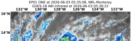
NHC升格01E
WTPZ41 KNHC 022037
TCDEP1
Tropical Depression One-E Discussion Number 1
NWS National Hurricane Center Miami FL EP012026
200 PM PDT Tue Jun 02 2026
The area of low pressure (90E) that NHC has been monitoring for
development has showed increased signs of organization today. An
area of sheared thunderstorm activity is observed to the north of
the low-level center, along with fragmented curved bands over the
northern portion of the circulation. Scatterometer wind data
revealed the system had a closed circulation, and its definition has
improved in recent passive microwave and visible satellite images.
Based on these developments, the NHC is initiating advisories on the
first tropical depression of the 2026 Eastern Pacific hurricane
season, with an initial intensity of 25 kt.
The depression is moving slowly westward (280/3 kt), but is expected
to move a bit faster toward the northwest during the next few days
along the southwestern side of a steering ridge over the central
portion of the basin. The track models are in very good agreement
for this portion of the forecast, and the official NHC prediction
lies between the simple and corrected-consensus aids. By days 4-5, a
slowdown is forecast as the system moves underneath the ridge and
steering currents collapse. There is increased track spread during
this period, although most models generally show a slow westward or
southwestward drift, which is reflected in the official forecast.
Warm sea-surface temperatures of 28-29 deg C and strong upper-level
divergence in a moist environment should allow for some
strengthening during the next couple of days or so. However,
easterly shear is forecast to increase by late week, which will
likely limit the extent of strengthening that occurs. The official
NHC forecast shows the system reaching tropical storm strength by
Wednesday, with a peak intensity in good agreement with the HCCA
consensus aid and the HAFS models. A weakening trend is forecast by
this weekend as the system encounters a drier and more stable
mid-level environment over cooler SSTs, and it is possible that the
system could become devoid of convection by the end of the period.
FORECAST POSITIONS AND MAX WINDS
INIT 02/2100Z 9.4N 126.7W 25 KT 30 MPH
12H 03/0600Z 9.9N 127.1W 30 KT 35 MPH
24H 03/1800Z 10.6N 128.2W 35 KT 40 MPH
36H 04/0600Z 11.5N 129.4W 40 KT 45 MPH
48H 04/1800Z 12.6N 130.8W 45 KT 50 MPH
60H 05/0600Z 13.3N 132.2W 50 KT 60 MPH
72H 05/1800Z 13.7N 133.3W 50 KT 60 MPH
96H 06/1800Z 13.7N 134.3W 40 KT 45 MPH
120H 07/1800Z 13.0N 135.5W 30 KT 35 MPH
$$
Forecaster Reinhart


|
|


 提升卡
提升卡 千斤頂
千斤頂 照妖鏡
照妖鏡