簽到天數: 3317 天 [LV.Master]伴壇終老
|
 king111807|2025-10-30 00:21
|
顯示全部樓層
king111807|2025-10-30 00:21
|
顯示全部樓層
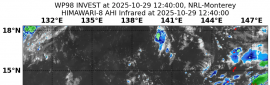
NHC降格C2
000
WTNT43 KNHC 291458
TCDAT3
Hurricane Melissa Discussion Number 33
NWS National Hurricane Center Miami FL AL132025
1100 AM EDT Wed Oct 29 2025
Melissa is moving back offshore, now in the Southwestern Atlantic
Ocean. The NOAA hurricane hunter aircraft flew around Cuba and more
recently was able to make a fix of Melissa just offshore. This
matches the latest view from the GOES-19 mesoscale sector and radar
out of Camaguey, Cuba. However, the smaller core that Melissa had
stubbornly maintained over the past few days has been destroyed by
the higher terrain of Cuba, and a larger core structure is
developing. This has led to a significant expansion of the 50-kt
wind radii on the eastern side of the hurricane. Land interaction
also appears to have lead to additional weakening of the the maximum
sustained winds that are now estimated to be around 85 kt, with the
pressure up to 974 mb based on the first NOAA-P3 aircraft fix. This
may still be a little generous given the aircraft wind data thus
far. An Air Force Reserve reconnaissance mission will also be
sampling Melissa later today.
The hurricane is continuing to slowly accelerate, now estimated to
be moving to the northeast at 030/12 kt. Melissa is expected to
continue accelerating northeastward during the next several days as
the hurricane is picked up by a very large an amplified upper-level
trough currently digging into the southeastern United States. This
motion will bring the core of the hurricane over portions of the
southeastern and central Bahamas over the next several hours. After
today, the track models remain tightly clustered on the center of
Melissa passing just to the northwest of Bermuda late Thursday and
Thursday night. The center of the hurricane is a little bit further
to the west emerging off Cuba, and the overall track guidance has
nudged a little bit further west this cycle, and the NHC track
forecast was also nudged in that direction, continuing to blend the
reliable consensus aids with the Google DeepMind ensemble mean
(GDMI).
Now that Melissa is back offshore, it has a short-term opportunity
for the hurricane to re-intensify a little as long as the larger
core that has developed is able to reorganize. Shear does start to
increase over the next 24-36 h, but the shear vector is also in the
same direction as the forward motion of the storm, which could
still allow some core reorganization of the convection while the
hurricane remains over warm 27-28 C sea-surface temperatures. Thus,
the short-term NHC forecast shows a little bit of intensification
over the next 12-24 h before weakening begins by 36 h.
Extratropical transition is expected to be well underway at or just
after Melissa passes by Bermuda, with the global model fields and
model-simulated satellite imagery show Melissa quickly losing
tropical characteristics and becoming an extratropical cyclone by 60
h. However, Melissa will still likely be a formidable extratropical
cyclone as it moves up into the Canadian Maritimes by this weekend
into early next week. The NHC intensity forecast is in good
agreement with the HAFS model guidance and HFIP Corrected Consensus
approach (HCCA).
Key Messages:
1. Eastern Cuba: Life-threatening storm surge, flash flooding and
landslides, and damaging winds are ongoing through this afternoon.
Remain in a safe shelter.
2. Bahamas and the Turks and Caicos: Hurricane conditions,
life-threatening storm surge, and heavy rainfall are expected across
portions of the southeastern and central Bahamas today. Find a safe
shelter and follow local official guidance. Tropical storm
conditions, heavy rains, and significant storm surge are expected in
the Turks and Caicos Islands today.
3. Haiti and the Dominican Republic: Catastrophic flash flooding and
landslides are expected across portions of Haiti and the Dominican
Republic through today. In Haiti, extensive damage and isolation of
communities is likely. Tropical storm conditions are expected
through this afternoon.
4. Bermuda: Hurricane conditions and heavy rainfall are expected in
Bermuda beginning late Thursday and continuing through Thursday
night.
5. Post-storm safety in impacted areas: Follow advice of local
officials as you may need to remain sheltered after the storm due to
downed power lines and flooded areas. Ensure generators are
properly ventilated and placed outside at least 20 feet away from
dwellings and garages to avoid carbon monoxide poisoning. During
clean up, be careful when using chainsaws and power tools. Drink
plenty of water to avoid heat exhaustion.
FORECAST POSITIONS AND MAX WINDS
INIT 29/1500Z 21.4N 75.6W 85 KT 100 MPH
12H 30/0000Z 23.4N 74.3W 90 KT 105 MPH
24H 30/1200Z 26.9N 71.9W 90 KT 105 MPH
36H 31/0000Z 31.6N 67.7W 85 KT 100 MPH
48H 31/1200Z 37.2N 61.8W 80 KT 90 MPH
60H 01/0000Z 43.3N 55.2W 65 KT 75 MPH...POST-TROP/EXTRATROP
72H 01/1200Z 49.0N 48.4W 55 KT 65 MPH...POST-TROP/EXTRATROP
96H 02/1200Z 55.0N 36.0W 50 KT 60 MPH...POST-TROP/EXTRATROP
120H 03/1200Z 58.8N 18.9W 45 KT 50 MPH...POST-TROP/EXTRATROP
$$
Forecaster Papin 

|
|


 照妖鏡
照妖鏡


.gif")