South of Southern Mexico (EP90):
A broad area of low pressure located near the coast of southern
Mexico is producing a large and persistent area of showers and
thunderstorms. Environmental conditions appear conducive for
gradual development of this system, and a tropical depression is
likely to form during the next couple of days as it moves
west-northwestward at 10 to 15 mph, roughly parallel to the coast of
southern and southwestern Mexico. Interests in these areas should
should monitor the progress of this system. Regardless of
development, the system is expected to produce periods of heavy
rainfall along portions of the southern and southwestern coasts of
Mexico through the end of the week, which could lead to localized
flooding.
* Formation chance through 48 hours...high...80 percent.
* Formation chance through 7 days...high...80 percent.
WTPN21 PHNC 080700
MSGID/GENADMIN/JOINT TYPHOON WRNCEN PEARL HARBOR HI//
SUBJ/TROPICAL CYCLONE FORMATION ALERT (INVEST 90E)//
RMKS/
1. FORMATION OF A SIGNIFICANT TROPICAL CYCLONE IS POSSIBLE WITHIN
095 NM EITHER SIDE OF A LINE FROM 14.5N 93.2W TO 16.0N 96.2W
WITHIN THE NEXT 12 TO 24 HOURS. AVAILABLE DATA DOES NOT JUSTIFY
ISSUANCE OF NUMBERED TROPICAL CYCLONE WARNINGS AT THIS TIME.
WINDS IN THE AREA ARE ESTIMATED TO BE 28 TO 33 KNOTS. METSAT
IMAGERY AT 080000Z INDICATES THAT A CIRCULATION CENTER IS LOCATED
NEAR 14.6N 93.4W. THE SYSTEM IS MOVING WEST-NORTHWESTWARD AT 07
KNOTS.
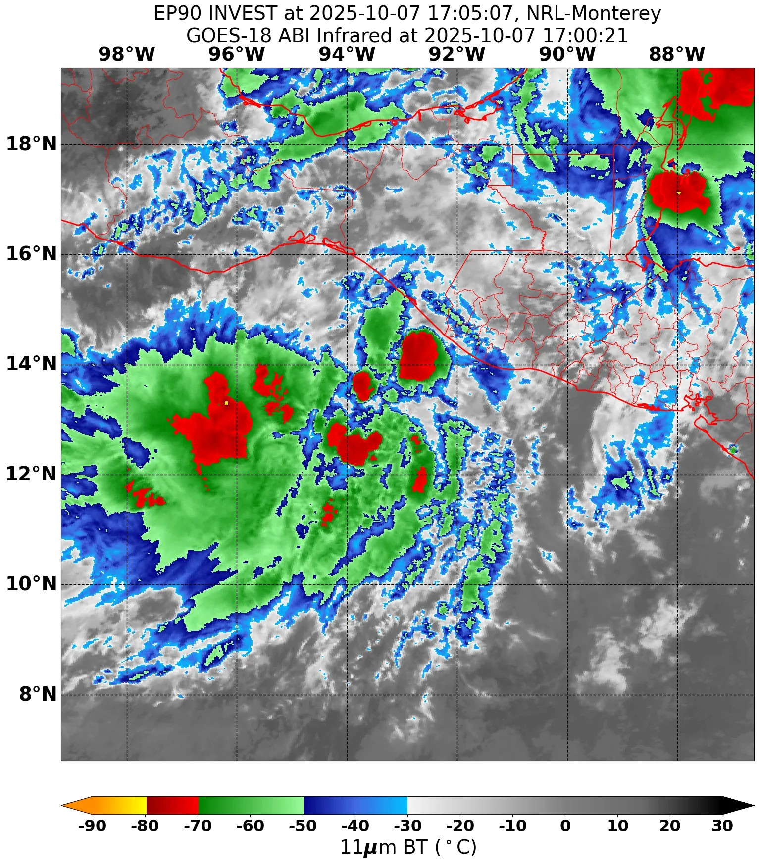
2. REMARKS: AN AREA OF CONVECTION (INVEST 90E) IS LOCATED NEAR
14.6N 93.4W, APPROXIMATELY 226NM EAST-SOUTHEAST OF PUNTA ESCONDIDA,
MEXICO. ANIMATED ENHANCED INFRARED IMAGERY (EIR) DEPICT A
CONSOLIDATING CIRCULATION WITH A LARGE AMOUNT OF FLARING CONVECTION
OVER THE CONSOLIDATING LLCC AND FORMATIVE BANDING ALONG THE SOUTHERN
PERIPHERY OF THE CIRCULATION. THE SYSTEM IS CHARACTERIZED BY FAVORABLE
ENVIRONMENTAL CONDITIONS WITH LOW (10-15KT) VERTICAL WIND SHEAR, WARM
(28-29C) SEA SURFACE TEMPS AND STRONG RADIAL OUTFLOW. GLOBAL
DETERMINISTIC AND ENSEMBLE MODELS ARE IN GOOD AGREEMENT THAT 90E WILL
FURTHER CONSOLIDATE AND TRACK WEST NORTH-WEST OVER THE NEXT 24-48 HOURS.
MAXIMUM SUSTAINED SURFACE WINDS ARE ESTIMATED AT 28 TO 33 KNOTS.MINIMUM
SEA LEVEL PRESSURE IS ESTIMATED TO BE NEAR 998 MB. THE POTENTIAL FOR THE
DEVELOPMENT OF A SIGNIFICANT TROPICAL CYCLONE WITHIN THE NEXT 24 HOURS
IS HIGH.
3. THIS ALERT WILL BE REISSUED, UPGRADED TO WARNING OR CANCELLED BY
090700Z.
//
NNNN
South of Southern Mexico (EP90):
A large and persistent area of showers and thunderstorms remains
disorganized near and to the west of a broad area of low pressure
located in the Gulf of Tehuantepec. Environmental conditions
appear conducive for gradual development over the next few days,
and a tropical depression is likely to form late this week if the
system remains over water. The disturbance is forecast to move
west-northwestward at 10 to 15 mph, roughly parallel to the coast
of southern and southwestern Mexico, and interests there should
monitor its progress. Regardless of development, the disturbance
is expected to produce periods of heavy rainfall along portions of
the southern and southwestern coasts of Mexico through the end of
the week, which could lead to localized flooding.
* Formation chance through 48 hours...high...70 percent.
* Formation chance through 7 days...high...80 percent.
South of Southern Mexico (EP90):
Showers and thunderstorms associated with a broad area of low
pressure located around 100 miles offshore of the Guatemala–Mexico
border remain disorganized. Environmental conditions are expected to
become more conducive for development over the next couple of days,
and a tropical depression is likely to form late this week if the
system remains over water. The disturbance is forecast to move
west-northwestward at 10 to 15 mph, roughly parallel to the coast of
southern and southwestern Mexico. Interests there should monitor the
progress of this system. Regardless of development, the disturbance
is expected to produce periods of heavy rainfall along portions of
the southern and southwestern coasts of Mexico through the end of
the week, which could lead to localized flooding.
* Formation chance through 48 hours...medium...60 percent.
* Formation chance through 7 days...high...80 percent.
South of Southern Mexico (EP90):
Showers and thunderstorms associated with a broad area of low
pressure located less than one hundred miles offshore of the
Guatemala–Mexico border remain disorganized. Environmental
conditions are expected to become more favorable for development of
this system over the next few days, and a tropical depression is
likely to form late this week if the system remains over water. The
disturbance is forecast to move west-northwestward at 10 to 15 mph,
near and parallel to the coast of southern Mexico. Interests along
the coast of southern Mexico should monitor the progress of this
system. Regardless of development, this system is likely to produce
periods of heavy rainfall along the southern coast of Mexico
through the end of the week.
* Formation chance through 48 hours...medium...50 percent.
* Formation chance through 7 days...high...80 percent.